Trail Trials: Camel's Hump
- Tim Murphy

- 19 hours ago
- 7 min read
Few landscapes in Vermont are as instantly recognizable as the twin peaks of Camel’s Hump. Standing 4,083 feet above sea level, this iconic summit dominates the skyline and preserves one of the region’s last remaining arctic-alpine ecosystems, drawing the curiosity of environmental researchers and outdoor enthusiasts alike.
Camel’s Hump has carried several names over the centuries, each reflecting a distinct chapter of its historical narrative. Prior to European contact, the indigenous Abenaki people knew the peak as Tawapodiiwajo (ta-wak-be-dee-ee-wadso), meaning “mountain seat.” During Samuel de Champlain’s regional expedition in 1609, French cartographers recorded the rugged profile as “Le Lion Couchant,” or “resting lion.” In 1798, Vermont statesman Ira Allen assigned the name “Camel’s Rump;” however, by 1830, the more pedestrian “Camel’s Hump” had become the mountain’s enduring moniker.

Camel’s Hump played a significant role in the cultural and geographic identity of the region, serving as a prominent waypoint for early tourism and outdoor recreation. The rise of Transcendentalist and Romantic ideals during the mid-nineteenth century fundamentally transformed American attitudes towards the natural world and inspired increasing numbers of people to visit sites like Camel’s Hump for both exploration and contemplation. By the 1860s, the mountain’s popularity had grown enough to support a summit house, an observatory, and a network of hiking trails—all built to accommodate the influx of visitors.
Although Camel’s Hump gained popularity among recreationists, its surrounding forests were being logged at an unprecedented pace, spurred by increased demand for timber and cleared land. Logging camps and sawmills sprang up in the valleys below, and extensive tracts of old-growth forest quickly disappeared as entrepreneurs exploited Vermont’s abundant natural resources—particularly red spruce, valued for manufacturing clapboards and shingles to meet the state’s growing population. Lumber companies clearcut forests as high as possible. By the 1880s, the supply of easily accessible spruce had been exhausted. But this scarcity didn’t slow the industry—instead, it pushed companies to innovate, with new mills processing various fir and hardwood species into pulpwood for paper production. By the end of the nineteenth century, unregulated logging had permanently altered Vermont’s landscape. Roughly eighty percent of the state was stripped of trees; almost no harvestable trees remained below 2,000 feet of elevation. Camel’s Hump itself was almost completely denuded, save for a few remote pockets near the summit.
In 1882, Colonel Joseph Battell—a prominent newspaper editor, book publisher, and philanthropist from Middlebury, Vermont—introduced a resolution to the State Legislature. Alarmed by the rapid depletion of Vermont’s forests, Battell called for the creation of a committee, operating under the Vermont Board of Agriculture, to investigate and report on the state’s forestry crisis. After two years of deliberation, the committee issued its findings. Its members saw little the state government could do, since the state owned almost no forestland, and were also reluctant to impose any restrictions that interfered with private property rights. Instead, they recommended education as the best means to promote better forest stewardship, hoping that informed citizens would voluntarily adopt more sustainable practices. Deeply disappointed by the committee’s findings, Battell used his considerable familial wealth to acquire large tracts of endangered Vermont forest, including Camel’s Hump.

Rampant deforestation had left the region dangerously prone to wildfires. One particularly destructive blaze in 1903 scorched thousands of acres around Camel’s Hump, intensifying calls for forest conservation. In 1908, a coalition of local landowners, hikers, and conservationists formed The Camel’s Hump Club to fulfill this critical need. Two years later, the Green Mountain Club was established with a similar mission: promoting responsible stewardship of Vermont’s natural resources. These grassroots organizations paved the way for broader initiatives, like the Vermont Forest Service, which oversaw reforestation efforts and implemented fire prevention measures. Fire lookout towers were constructed on prominent peaks, manned by vigilant observers who could quickly detect and report suspected blazes. Tree nurseries cultivated seedlings to rehabilitate devastated landscapes, gradually reviving Vermont’s forests after decades of abuse. Together, these measures marked the beginning of a coordinated conservation movement in Vermont, transforming public attitudes and laying the groundwork for modern environmental protections.
In 1911, Battell entrusted the Vermont Forest Service with one thousand undeveloped acres around Camel's Hump summit, creating one of the state’s earliest public reserves. In 1968, the National Park Service designated Camel's Hump as a National Natural Landmark, recognizing the peak as "an exceptional illustration of the complex anticlinal deformation which formed the Green Mountains." Today, Camel’s Hump State Park encompasses over 21,000 acres, protecting fragile ecosystems, supporting diverse wildlife, and offering a range of recreational opportunities.

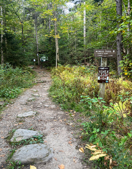
The topographic profile of Camel's Hump presents a demanding yet gratifying challenge for hikers of all experience levels. The mountain’s extensive trail network traverses lush forests and alpine terrain, culminating in breathtaking scenic viewpoints of Lake Champlain and the surrounding Green Mountains. Several approaches lead to the summit, but most popular option is the Monroe Trail in North Duxbury. Marked by blue blazes, this route extends approximately three miles one way and climbs nearly 2,600 feet, providing hikers with a moderately strenuous ascent along the mountain’s eastern slope.
The Monroe Trail is named after Will Monroe, a key figure in Vermont’s early recreational development. A literal trailblazer, Monroe helped extend the Long Trail—the nation’s oldest long-distance hiking route—south from Camel's Hump to Middlebury Gap in 1916. Will, his sister Catherine, and several family pets are buried in a small cemetery plot beside the trailhead parking lot.
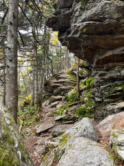
Although the alpine region attracts most hikers, the Monroe Trail traverses several distinct ecological zones. The lower sections wind through hardwood and boreal forests, marked by broad stands of paper birch. Spruce and fir trees gradually become more prominent at higher altitudes.

Despite extensive logging practices and numerous wildfires, Camel's Hump still supports substantial spruce populations, thanks to reforestations efforts by the Vermont Forest Service. However, during the 1960s, researchers observed a marked decline of red spruce along the mountain’s westerns slope. This phenomenon became the focus of investigation for Hub Vogelmann and his graduate students at the University of Vermont. Their findings, published in Vogelmann’s 1982 paper “Catastrophe on Camel’s Hump,” identified acid rain as the primary cause, connecting local ecological changes to broader patterns of atmospheric pollution. This groundbreaking research heightened environmental awareness and ultimately influenced the Clean Air Act Amendments of 1990.
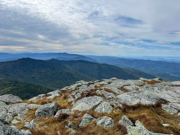
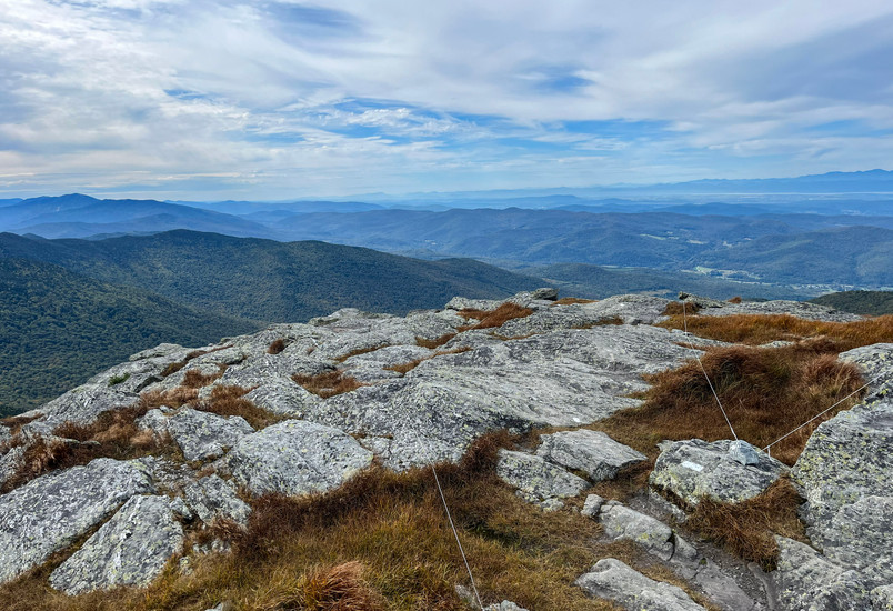
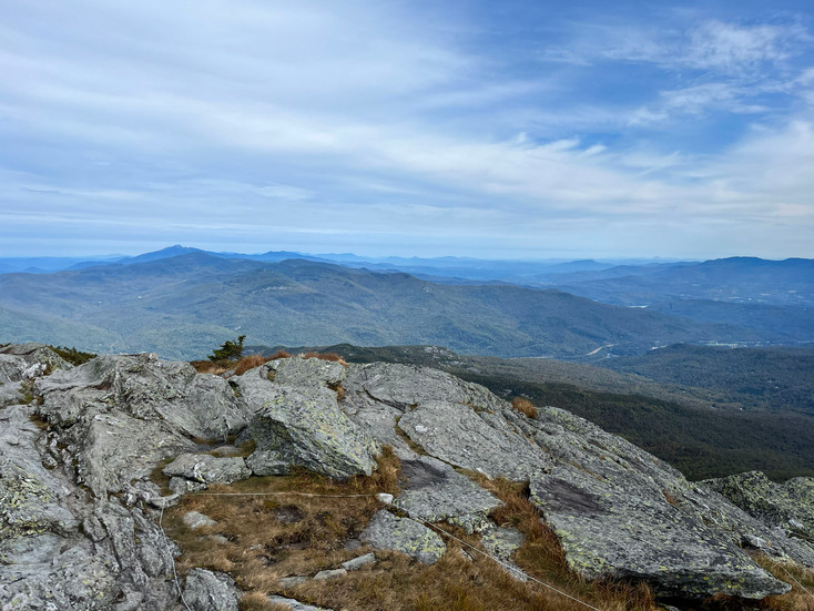
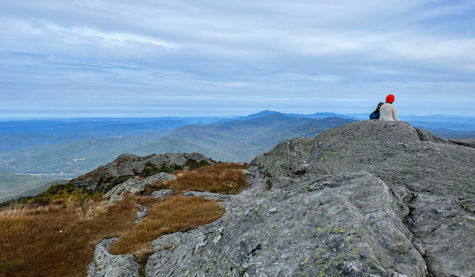
The Monroe Trail terminates at Hut Clearing, where it joins the white-blazed Long Trail. From this junction, hikers ascend another 0.3 miles to reach the summit of Camel’s Hump, which fosters a delicate arctic-alpine ecosystem—one of only three such locations in Vermont’s Green Mountains.
When glaciers receded from the region nearly 10,000 years ago, they exposed a rugged terrain resembling an Arctic tundra, dominated by resilient shrubs, mosses, and grass-like plants. As the climate warmed, woodlands gradually overtook much of the landscape. Yet, on summits like Camel’s Hump, extreme conditions—such as harsh winds, shallow soils, and frigid temperatures—kept forests at bay, preserving this ancient and endangered ecosystem. Alpine zones remain especially vulnerable on Camel’s Hump, where persistent foot traffic places significant strain on these fragile environments. Visitors are encouraged to tread carefully across the summit and respect trail boundaries, as responsible recreation helps support ongoing conservation efforts.

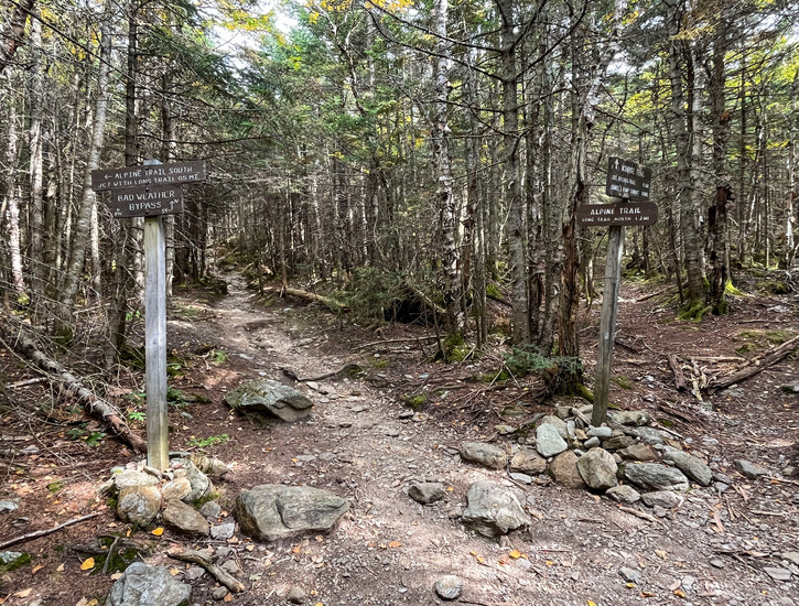
The Long Trail sharply descends the craggy western face of Camel’s Hump, revealing an expansive forested vista with Lake Champlain visible on the horizon. After approximately 0.4 miles, the route intersects with the yellow-blazed Alpine Trail. Continue along this connector for another half-mile to return to the Monroe Trail.
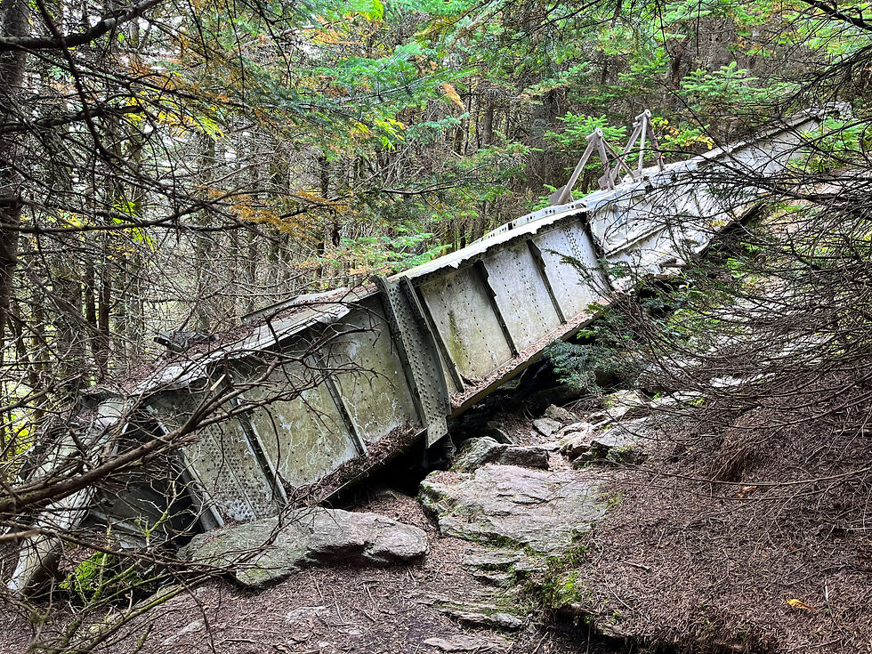
Along the Alpine Trail, hikers may encounter the remains of a B-24J Liberator bomber that crashed here on October 16, 1944. The aircraft was conducting a routine training mission from Westover Air Force Base in Chicopee, Massachusetts, when it collided with Camel’s Hump. The morning after the accident, military personnel and Civil Air Patrol teams launched an extensive search, but dense cloud cover hindered efforts at higher elevations. When the skies cleared on the second day, an Army reconnaissance plane finally spotted the wreckage perched on the mountain’s southeastern slope.
Nine servicemen perished in the tragic Liberator accident: First Lieutenant David E. Potter (pilot); Flight Officer John J. Ramasocky (co-pilot); Second Lieutenant Robert W. Geoffery; First Lieutenant David C. McNary; Corporal Luther N. Hagler; Corporal James Perry; Corporal Robert E. Denton; Private First Class Richard C. Wynne; and Private First Class Casper Zacher. Against extraordinary odds, nineteen-year-old Private First Class James W. Wilson emerged as the sole surviving crew member. Although he lost both hands and feet from severe frostbite, Wilson eventually made a full recovery and went on to establish a successful law practice in Denver, Colorado.
While most of the warplane was salvaged and removed, portions of the debris field remain, including a largely-intact aluminum wing section. A short spur trail now guides visitors to the crash site, lending a somber dimension to the mountain’s otherwise scenic beauty.
Once the Alpine Trail rejoins the Monroe Trail, it is a 2.5-mile descent back to the parking area. Altogether, the Camel’s Hump hike via the Monroe Trail covers 6.7 miles and typically takes between three and four hours to complete.
Camel’s Hump stands out as one of Vermont’s most distinctive landmarks, captivating hikers and conservationists across generations. The mountain’s largely undeveloped alpine ecosystem provides a critical habitat for rare plant species, highlighting its significance as both a unique natural sanctuary and model for effective environmental stewardship. For those visiting the Green Mountains, climbing Camel’s Hump is not just a scenic adventure, but also a journey into the heart of Vermont’s natural and cultural heritage. Trail Rating: 10/10


Visit the Green Mountain Club or reference this trail guide to learn more about the recreational opportunities at Camel's Hump State Park
For more hiking reviews, visit Vermonter.com and Valley News
Check out this Cultural Landscape Report to learn more about the history of Camel's Hump and its ecological significance
For more information about the Liberator bomber tragedy, visit the National Association of Science Writers, VT Digger, and Vermont Archives Month


